Culter Fell Donalds
Culter, Fell, Donalds
- Distance: 9.8 mi
- Elevation gain: 954 m
- Maximum elevation: 743 m
- Elevation loss: 954 m
- Minimum elevation: 269 m
- Moving time: 4 h 51 m
- Moving speed: 2.0 mph
- Maximum speed: 5.9 mph
- Total time: 5 h 18 m
- Global speed: 1.9 mph
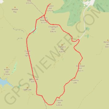
Interactive trail map
Trail profile
- Distance: 9.8 mi
- Elevation gain: 954 m
- Maximum elevation: 743 m
- Elevation loss: 954 m
- Minimum elevation: 269 m
- Moving time: 4 h 51 m
- Moving speed: 2.0 mph
- Maximum speed: 5.9 mph
- Total time: 5 h 18 m
- Global speed: 1.9 mph
About this trail
Name: Culter Fell Donalds trail, distance, elevation, map, profile, GPS track
Start: Scottish Borders, Scotland, ML12 6QL, United Kingdom (55.55075 -3.45841)
End: Scottish Borders, Scotland, ML12 6QL, United Kingdom (55.55076 -3.45833)
Coordinates: 55.51879 -3.50355 55.56794 -3.45522
Topography: Scottish Borders topographic map, elevation, terrain