Munro hillwalk Cairngorm and northern corries
- Distance: 9.1 mi
- Elevation gain: 912 m
- Maximum elevation: 1,244 m
- Elevation loss: 911 m
- Minimum elevation: 624 m
- Moving time: 4 h 36 m
- Moving speed: 2.0 mph
- Maximum speed: 3.6 mph
- Total time: 5 h 7 m
- Global speed: 1.8 mph
Interactive trail map
Trail profile
- Distance: 9.1 mi
- Elevation gain: 912 m
- Maximum elevation: 1,244 m
- Elevation loss: 911 m
- Minimum elevation: 624 m
- Moving time: 4 h 36 m
- Moving speed: 2.0 mph
- Maximum speed: 3.6 mph
- Total time: 5 h 7 m
- Global speed: 1.8 mph
About this trail
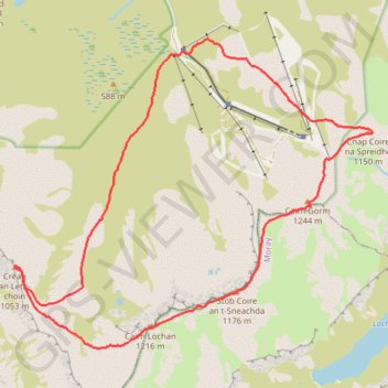
Name: Munro hillwalk Cairngorm and northern corries trail, distance, elevation, map, profile, GPS track
Coordinates: 57.10026 -3.70491 57.13494 -3.63099
Topography: Highland topographic map, elevation, terrain
Other hiking, mountain biking, running and outdoor activity trails
Click on a trail to view its statistics, map and profile.
Cairngorms hike
United Kingdom > Scotland > Highland > Aviemore
Distance: 50.2 mi • Elevation gain: 3,001 m • Maximum elevation: 1,312 m