Import a GPX file

Terrace / Indian Ridge Trail

  • Distance: 3.3 mi
  • Elevation gain: 45 m
  • Maximum elevation: 288 m
  • Elevation loss: 68 m
  • Minimum elevation: 252 m
  • Moving time: 49 m 34 s
  • Moving speed: 4.0 mph
  • Maximum speed: 9.0 mph
  • Total time: 49 m 34 s
  • Global speed: 4.0 mph

Interactive trail map

Trail profile

  • Distance: 3.3 mi
  • Elevation gain: 45 m
  • Maximum elevation: 288 m
  • Elevation loss: 68 m
  • Minimum elevation: 252 m
  • Moving time: 49 m 34 s
  • Moving speed: 4.0 mph
  • Maximum speed: 9.0 mph
  • Total time: 49 m 34 s
  • Global speed: 4.0 mph

About this trail
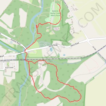
Name: Terrace / Indian Ridge Trail trail, distance, elevation, map, profile, GPS track

Start: Darby Creek Greenway Trail, Pleasant Township, Franklin County, Ohio, 43119, United States (39.90184 -83.20964)

End: Camp Chase Trail, Georgesville, Pleasant Township, Franklin County, Ohio, United States (39.89172 -83.21635)

Coordinates: 39.88457 -83.21710 39.90184 -83.20419

Gear up for your next adventure:

🧢Waterproof Hiking Hats - Keep the rain off your face while studying topographic maps
🌂Windproof Trekking Umbrellas - Surprising but effective rain protection on low-wind trails
🔦Outdoor Torches - Reliable torches for night navigation
📍Handheld GPS Navigators - Reliable satellite navigation for hiking and off-road exploration
🎒Hiking Daypacks - Compact backpacks ideal for short hikes and excursions

As an Amazon Associate, this site earns from qualifying purchases at no extra cost to you.