Thank you for supporting this site ❤️
Make a donation
Make a donation
Gear up for your next adventure:
As an Amazon Associate, this site earns from qualifying purchases at no extra cost to you.
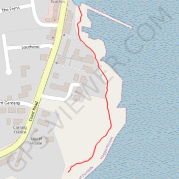
Footpath
- Distance: 0.2 mi
- Elevation gain: 2 m
- Maximum elevation: 3 m
- Elevation loss: 3 m
- Minimum elevation: 0 m
- Moving time: 4 m 26 s
- Moving speed: 3.3 mph
- Maximum speed: 4.1 mph
- Total time: 4 m 26 s
- Global speed: 3.3 mph
Interactive trail map
Thank you for supporting this site ❤️
Make a donation
Make a donation
Gear up for your next adventure:
As an Amazon Associate, this site earns from qualifying purchases at no extra cost to you.
Trail profile
- Distance: 0.2 mi
- Elevation gain: 2 m
- Maximum elevation: 3 m
- Elevation loss: 3 m
- Minimum elevation: 0 m
- Moving time: 4 m 26 s
- Moving speed: 3.3 mph
- Maximum speed: 4.1 mph
- Total time: 4 m 26 s
- Global speed: 3.3 mph
Thank you for supporting this site ❤️
Make a donation
Make a donation
Gear up for your next adventure:
As an Amazon Associate, this site earns from qualifying purchases at no extra cost to you.
About this trail
Name: Footpath trail, distance, elevation, map, profile, GPS track
Start: Haggardstown ED, Dundalk, County Louth, Leinster, A91 H9X3, Ireland (53.95765 -6.36711)
Coordinates: 53.95765 -6.36711 53.96057 -6.36581
Thank you for supporting this site ❤️
Make a donation
Make a donation
Gear up for your next adventure:
As an Amazon Associate, this site earns from qualifying purchases at no extra cost to you.