Import a GPX file

Peekaboo Camp

Hike to Peekaboo Camp via Squaw Canyon Trail, Peekaboo Trail and Salt Creek Canyon Trailhead in the Needles District and the Canyonlands National Park. #Hiking #Nature #Rock #Park

  • Distance: 11.3 mi
  • Elevation gain: 620 m
  • Maximum elevation: 1,656 m
  • Elevation loss: 616 m
  • Minimum elevation: 1,532 m
  • Moving time: 4 h 5 m
  • Moving speed: 2.8 mph
  • Maximum speed: 14.4 mph
  • Total time: 4 h 30 m
  • Global speed: 2.5 mph

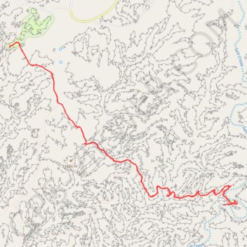
Interactive trail map

Trail profile

  • Distance: 11.3 mi
  • Elevation gain: 620 m
  • Maximum elevation: 1,656 m
  • Elevation loss: 616 m
  • Minimum elevation: 1,532 m
  • Moving time: 4 h 5 m
  • Moving speed: 2.8 mph
  • Maximum speed: 14.4 mph
  • Total time: 4 h 30 m
  • Global speed: 2.5 mph

About this trail

Other hiking, mountain biking, running and outdoor activity trails

Click on a trail to view its statistics, map and profile.

Squaw Canyon Loop

United States > Utah > San Juan County

Loop hike on Quaw Canyon Trail, Wooden Shoe Canyon Trail and Big Spring Canyon Trail in the Canyonlands National Park. #Hiking #Loop #Canyon #Mountain #Nature #Park

Distance: 7.4 mi • Elevation gain: 257 m • Maximum elevation: 1,714 m

Hiking Canyonlands Needles

United States > Utah > San Juan County

Loop hike via Squaw Flat Loop, Big Spring Canyon Trail in the Needles Districtand and the Canyonlands National Park. #Hiking #Loop #Nature #Rock #Park

Distance: 2.2 mi • Elevation gain: 112 m • Maximum elevation: 1,614 m

Gear up for your next adventure:

🛌Sleeping Bags - Warm and packable sleeping bags for outdoor nights
🖼️Topographic Map Art - Decorative 3D-effect posters of famous UK peaks and regions
👟Waterproof Leg Gaiters - Keep mud and water out of your boots in boggy terrain
👟Women's Trail Running Shoes - Agile footwear for fell running and technical trails
🎒Hiking Daypacks (20L) - Compact backpacks for day trips and technical mountain ascents

As an Amazon Associate, this site earns from qualifying purchases at no extra cost to you.