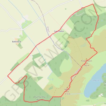
Around Keillor Hill
- Distance: 5.6 mi
- Elevation gain: 234 m
- Maximum elevation: 330 m
- Elevation loss: 233 m
- Minimum elevation: 109 m
- Moving time: 1 h 14 m
- Moving speed: 4.5 mph
- Maximum speed: 17.7 mph
- Total time: 1 h 21 m
- Global speed: 4.2 mph
Interactive trail map
Trail profile
- Distance: 5.6 mi
- Elevation gain: 234 m
- Maximum elevation: 330 m
- Elevation loss: 233 m
- Minimum elevation: 109 m
- Moving time: 1 h 14 m
- Moving speed: 4.5 mph
- Maximum speed: 17.7 mph
- Total time: 1 h 21 m
- Global speed: 4.2 mph
About this trail
Name: Around Keillor Hill trail, distance, elevation, map, profile, GPS track
Coordinates: 56.52965 -3.19742 56.55388 -3.15692
Topography: Perth and Kinross topographic map, elevation, terrain
Other hiking, mountain biking, running and outdoor activity trails
Click on a trail to view its statistics, map and profile.
Mountain Bike Ride Around Westerkeith Hill
United Kingdom > Scotland > Perth and Kinross > Piperdam > South Dronley
Loop MTB via Drumsuldry Wood, Westerkeith Hill, Ledcrieff Loch, Ledcrieff Wood and Lundiecraigs Wood. #MTB #Loop #Nature #Forest #Countryside
Distance: 6.2 mi • Elevation gain: 279 m • Maximum elevation: 343 m