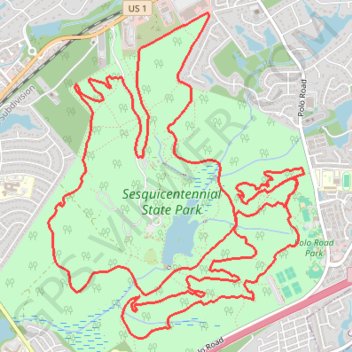
Sesquicentennial State Park Loop
Loop run / hike in the Sesquicentennial State Park via Loop Trail and Sesqui Mountain Bike Trail. #Running #Hiking #Loop #Park #Nature #Forest #Lake
- Distance: 12.6 mi
- Elevation gain: 228 m
- Maximum elevation: 141 m
- Elevation loss: 228 m
- Minimum elevation: 80 m
- Moving time: 1 h 39 m
- Moving speed: 7.6 mph
- Maximum speed: 23.2 mph
- Total time: 1 h 45 m
- Global speed: 7.2 mph
Interactive trail map
Trail profile
- Distance: 12.6 mi
- Elevation gain: 228 m
- Maximum elevation: 141 m
- Elevation loss: 228 m
- Minimum elevation: 80 m
- Moving time: 1 h 39 m
- Moving speed: 7.6 mph
- Maximum speed: 23.2 mph
- Total time: 1 h 45 m
- Global speed: 7.2 mph
About this trail
Name: Sesquicentennial State Park Loop trail, distance, elevation, map, profile, GPS track
Start: Loop Trail, Richland County, South Carolina, 29223, United States (34.09156 -80.90805)
End: Loop Trail, Richland County, South Carolina, 29223, United States (34.09148 -80.90811)
Coordinates: 34.07700 -80.91723 34.10312 -80.89250