Thank you for supporting this site ❤️
Make a donation
Make a donation
Gear up for your next adventure:
As an Amazon Associate, this site earns from qualifying purchases at no extra cost to you.
BM 24 - 42km 12_01_24
- Distance: 26.1 mi
- Elevation gain: 171 m
- Maximum elevation: 80 m
- Elevation loss: 170 m
- Minimum elevation: 25 m
Interactive trail map
Thank you for supporting this site ❤️
Make a donation
Make a donation
Gear up for your next adventure:
As an Amazon Associate, this site earns from qualifying purchases at no extra cost to you.
Trail profile
- Distance: 26.1 mi
- Elevation gain: 171 m
- Maximum elevation: 80 m
- Elevation loss: 170 m
- Minimum elevation: 25 m
Thank you for supporting this site ❤️
Make a donation
Make a donation
Gear up for your next adventure:
As an Amazon Associate, this site earns from qualifying purchases at no extra cost to you.
About this trail
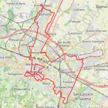
Name: BM 24 - 42km 12_01_24 trail, distance, elevation, map, profile, GPS track
Coordinates: 44.46463 11.33085 44.55553 11.40567
Thank you for supporting this site ❤️
Make a donation
Make a donation
Gear up for your next adventure:
As an Amazon Associate, this site earns from qualifying purchases at no extra cost to you.