Thank you for supporting this site ❤️
Make a donation
Make a donation
Gear up for your next adventure:
As an Amazon Associate, this site earns from qualifying purchases at no extra cost to you.
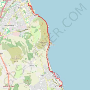
Bray - Greystones
- Distance: 11.2 mi
- Elevation gain: 511 m
- Maximum elevation: 74 m
- Elevation loss: 511 m
- Minimum elevation: 0 m
Interactive trail map
Thank you for supporting this site ❤️
Make a donation
Make a donation
Gear up for your next adventure:
As an Amazon Associate, this site earns from qualifying purchases at no extra cost to you.
Trail profile
- Distance: 11.2 mi
- Elevation gain: 511 m
- Maximum elevation: 74 m
- Elevation loss: 511 m
- Minimum elevation: 0 m
Thank you for supporting this site ❤️
Make a donation
Make a donation
Gear up for your next adventure:
As an Amazon Associate, this site earns from qualifying purchases at no extra cost to you.
About this trail
Name: Bray - Greystones trail, distance, elevation, map, profile, GPS track
Coordinates: 53.14418 -6.10109 53.20458 -6.05998
Thank you for supporting this site ❤️
Make a donation
Make a donation
Gear up for your next adventure:
As an Amazon Associate, this site earns from qualifying purchases at no extra cost to you.