Brighton - Adelaide
#Bike
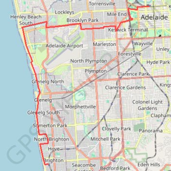
- Distance: 14.6 mi
- Elevation gain: 101 m
- Maximum elevation: 53 m
- Elevation loss: 60 m
- Minimum elevation: -1 m
Interactive trail map
Trail profile
- Distance: 14.6 mi
- Elevation gain: 101 m
- Maximum elevation: 53 m
- Elevation loss: 60 m
- Minimum elevation: -1 m
About this trail
Name: Brighton - Adelaide trail, distance, elevation, map, profile, GPS track
Coordinates: -35.02125 138.49821 -34.92157 138.59638
Other hiking, mountain biking, running and outdoor activity trails
Click on a trail to view its statistics, map and profile.
Belair National Park - Goodwood
Australia > South Australia > Adelaide
#Bike
Distance: 7.8 mi • Elevation gain: 36 m • Maximum elevation: 324 m