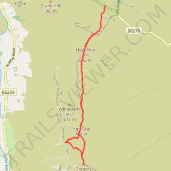
High Pike Hill, High Seat and Gregory Chapel hike in Yorkshire Dales National Park
- Distance: 6.1 mi
- Elevation gain: 342 m
- Maximum elevation: 710 m
- Elevation loss: 342 m
- Minimum elevation: 498 m
- Moving time: 3 h 46 m
- Moving speed: 1.6 mph
- Maximum speed: 2.8 mph
- Total time: 5 h 43 m
- Global speed: 1.1 mph
Interactive trail map
Trail profile
- Distance: 6.1 mi
- Elevation gain: 342 m
- Maximum elevation: 710 m
- Elevation loss: 342 m
- Minimum elevation: 498 m
- Moving time: 3 h 46 m
- Moving speed: 1.6 mph
- Maximum speed: 2.8 mph
- Total time: 5 h 43 m
- Global speed: 1.1 mph
About this trail
Name: High Pike Hill, High Seat and Gregory Chapel hike in Yorkshire Dales National Park trail, distance, elevation, map, profile, GPS track
Coordinates: 54.39697 -2.31284 54.43352 -2.29670
Topography: Westmorland and Furness topographic map, elevation, terrain