Thank you for supporting this site ❤️
Make a donation
Make a donation
Gear up for your next adventure:
As an Amazon Associate, this site earns from qualifying purchases at no extra cost to you.
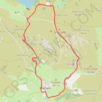
Malham - Yorkshire Dales National Park
Interactive trail map
Thank you for supporting this site ❤️
Make a donation
Make a donation
Gear up for your next adventure:
As an Amazon Associate, this site earns from qualifying purchases at no extra cost to you.
Trail profile
- Distance: 7.0 mi
- Elevation gain: 274 m
- Maximum elevation: 391 m
- Elevation loss: 273 m
- Minimum elevation: 192 m
Thank you for supporting this site ❤️
Make a donation
Make a donation
Gear up for your next adventure:
As an Amazon Associate, this site earns from qualifying purchases at no extra cost to you.
About this trail
Name: Malham - Yorkshire Dales National Park trail, distance, elevation, map, profile, GPS track
Coordinates: 54.05743 -2.16776 54.09364 -2.13044
Topography: North Yorkshire topographic map, elevation, terrain
Thank you for supporting this site ❤️
Make a donation
Make a donation
Gear up for your next adventure:
As an Amazon Associate, this site earns from qualifying purchases at no extra cost to you.
Other hiking, mountain biking, running and outdoor activity trails
Click on a trail to view its statistics, map and profile.
Riverside Path, Gordale Scar, Malham Tarn and Watlowes Loop
United Kingdom > England > North Yorkshire > Malham
Distance: 9.0 mi • Elevation gain: 458 m • Maximum elevation: 392 m