Make a donation
Gear up for your next adventure:
As an Amazon Associate, this site earns from qualifying purchases at no extra cost to you.
John O'Groats Trail - Brora to Helmsdale
- Distance: 13.3 mi
- Elevation gain: 249 m
- Maximum elevation: 100 m
- Elevation loss: 255 m
- Minimum elevation: 0 m
- Moving time: 5 h 35 m
- Moving speed: 2.4 mph
- Maximum speed: 4.1 mph
- Total time: 6 h 25 m
- Global speed: 2.1 mph
Interactive trail map
Make a donation
Gear up for your next adventure:
As an Amazon Associate, this site earns from qualifying purchases at no extra cost to you.
Trail profile
- Distance: 13.3 mi
- Elevation gain: 249 m
- Maximum elevation: 100 m
- Elevation loss: 255 m
- Minimum elevation: 0 m
- Moving time: 5 h 35 m
- Moving speed: 2.4 mph
- Maximum speed: 4.1 mph
- Total time: 6 h 25 m
- Global speed: 2.1 mph
Make a donation
Gear up for your next adventure:
As an Amazon Associate, this site earns from qualifying purchases at no extra cost to you.
About this trail
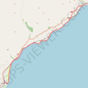
Name: John O'Groats Trail - Brora to Helmsdale trail, distance, elevation, map, profile, GPS track
Coordinates: 58.01074 -3.85498 58.11610 -3.65085
Topography: Highland topographic map, elevation, terrain
Make a donation
Gear up for your next adventure:
As an Amazon Associate, this site earns from qualifying purchases at no extra cost to you.
Other hiking, mountain biking, running and outdoor activity trails
Click on a trail to view its statistics, map and profile.
John O'Groats Trail - Helmsdale to Berriedale
United Kingdom > Scotland > Highland > Helmsdale
Distance: 10.9 mi • Elevation gain: 811 m • Maximum elevation: 213 m
Dunbeath - Dornoch
United Kingdom > Scotland > Highland > Houstry
Distance: 45.3 mi • Elevation gain: 898 m • Maximum elevation: 230 m