Beckenham Place Park
Morning Walk
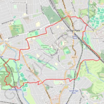
- Distance: 7.2 mi
- Elevation gain: 132 m
- Maximum elevation: 67 m
- Elevation loss: 132 m
- Minimum elevation: 27 m
- Moving time: 2 h 31 m
- Moving speed: 2.8 mph
- Maximum speed: 4.5 mph
- Total time: 2 h 34 m
- Global speed: 2.8 mph
Interactive trail map
Trail profile
- Distance: 7.2 mi
- Elevation gain: 132 m
- Maximum elevation: 67 m
- Elevation loss: 132 m
- Minimum elevation: 27 m
- Moving time: 2 h 31 m
- Moving speed: 2.8 mph
- Maximum speed: 4.5 mph
- Total time: 2 h 34 m
- Global speed: 2.8 mph
About this trail
Name: Beckenham Place Park trail, distance, elevation, map, profile, GPS track
Coordinates: 51.41401 -0.01305 51.43646 0.03459
Topography: London topographic map, elevation, terrain
Other hiking, mountain biking, running and outdoor activity trails
Click on a trail to view its statistics, map and profile.
Mottingham, Chinbrook
United Kingdom > England > London
Morning Walk
Distance: 4.5 mi • Elevation gain: 89 m • Maximum elevation: 79 m