Make a donation
Gear up for your next adventure:
As an Amazon Associate, this site earns from qualifying purchases at no extra cost to you.
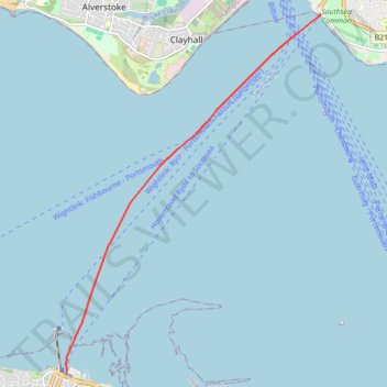
Hovertravel Ryde to Southsea
- Distance: 4.6 mi
- Elevation gain: 2 m
- Maximum elevation: 2 m
- Elevation loss: 2 m
- Minimum elevation: 0 m
- Moving time: 9 m 1 s
- Moving speed: 30.3 mph
- Maximum speed: 36.1 mph
- Total time: 10 m 18 s
- Global speed: 26.5 mph
Interactive trail map
Make a donation
Gear up for your next adventure:
As an Amazon Associate, this site earns from qualifying purchases at no extra cost to you.
Trail profile
- Distance: 4.6 mi
- Elevation gain: 2 m
- Maximum elevation: 2 m
- Elevation loss: 2 m
- Minimum elevation: 0 m
- Moving time: 9 m 1 s
- Moving speed: 30.3 mph
- Maximum speed: 36.1 mph
- Total time: 10 m 18 s
- Global speed: 26.5 mph
Make a donation
Gear up for your next adventure:
As an Amazon Associate, this site earns from qualifying purchases at no extra cost to you.
About this trail
Name: Hovertravel Ryde to Southsea trail, distance, elevation, map, profile, GPS track
End: Clarence Esplanade, Old Portsmouth, Portsmouth, England, PO5 3PB, United Kingdom (50.78494 -1.09988)
Coordinates: 50.73275 -1.15856 50.78494 -1.09988
Topography: Isle of Wight topographic map, elevation, terrain
Make a donation
Gear up for your next adventure:
As an Amazon Associate, this site earns from qualifying purchases at no extra cost to you.
Other hiking, mountain biking, running and outdoor activity trails
Click on a trail to view its statistics, map and profile.
Ryde loop - Isle of Wight
United Kingdom > England > Isle of Wight > Wootton Bridge
Distance: 10.2 mi • Elevation gain: 237 m • Maximum elevation: 53 m