Thank you for supporting this site ❤️
Make a donation
Make a donation
Gear up for your next adventure:
As an Amazon Associate, this site earns from qualifying purchases at no extra cost to you.
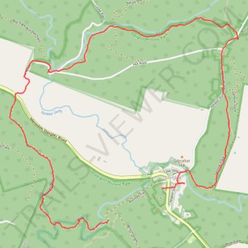
Steiglitz Historic Park Circuit
- Distance: 4.9 mi
- Elevation gain: 210 m
- Maximum elevation: 318 m
- Elevation loss: 183 m
- Minimum elevation: 206 m
Interactive trail map
Thank you for supporting this site ❤️
Make a donation
Make a donation
Gear up for your next adventure:
As an Amazon Associate, this site earns from qualifying purchases at no extra cost to you.
Trail profile
- Distance: 4.9 mi
- Elevation gain: 210 m
- Maximum elevation: 318 m
- Elevation loss: 183 m
- Minimum elevation: 206 m
Thank you for supporting this site ❤️
Make a donation
Make a donation
Gear up for your next adventure:
As an Amazon Associate, this site earns from qualifying purchases at no extra cost to you.
About this trail
Name: Steiglitz Historic Park Circuit trail, distance, elevation, map, profile, GPS track
Start: Burchell Trail, Steiglitz, Golden Plains Shire, Victoria, 3331, Australia (-37.87975 144.17206)
End: Williams Street, Steiglitz, Golden Plains Shire, Victoria, 3331, Australia (-37.87704 144.17794)
Coordinates: -37.88060 144.16134 -37.86242 144.18622
Thank you for supporting this site ❤️
Make a donation
Make a donation
Gear up for your next adventure:
As an Amazon Associate, this site earns from qualifying purchases at no extra cost to you.