Thank you for supporting this site ❤️
Make a donation
Make a donation
Gear up for your next adventure:
As an Amazon Associate, this site earns from qualifying purchases at no extra cost to you.
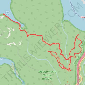
Muogamarra Nature Preserve - Western Lookout, Tipper Lookout, Peats Bight, Lloyd Trig, Deerubbin Lookover
- Distance: 10.4 mi
- Elevation gain: 561 m
- Maximum elevation: 221 m
- Elevation loss: 554 m
- Minimum elevation: 1 m
- Moving time: 4 h 10 m
- Moving speed: 2.5 mph
- Maximum speed: 12.9 mph
- Total time: 5 h 56 m
- Global speed: 1.7 mph
Interactive trail map
Thank you for supporting this site ❤️
Make a donation
Make a donation
Gear up for your next adventure:
As an Amazon Associate, this site earns from qualifying purchases at no extra cost to you.
Trail profile
- Distance: 10.4 mi
- Elevation gain: 561 m
- Maximum elevation: 221 m
- Elevation loss: 554 m
- Minimum elevation: 1 m
- Moving time: 4 h 10 m
- Moving speed: 2.5 mph
- Maximum speed: 12.9 mph
- Total time: 5 h 56 m
- Global speed: 1.7 mph
Thank you for supporting this site ❤️
Make a donation
Make a donation
Gear up for your next adventure:
As an Amazon Associate, this site earns from qualifying purchases at no extra cost to you.
About this trail
Name: Muogamarra Nature Preserve - Western Lookout, Tipper Lookout, Peats Bight, Lloyd Trig, Deerubbin Lookover trail, distance, elevation, map, profile, GPS track
Coordinates: -33.55472 151.16091 -33.53442 151.19424
Thank you for supporting this site ❤️
Make a donation
Make a donation
Gear up for your next adventure:
As an Amazon Associate, this site earns from qualifying purchases at no extra cost to you.
Other hiking, mountain biking, running and outdoor activity trails
Click on a trail to view its statistics, map and profile.