Thank you for supporting this site ❤️
Make a donation
Make a donation
Gear up for your next adventure:
As an Amazon Associate, this site earns from qualifying purchases at no extra cost to you.
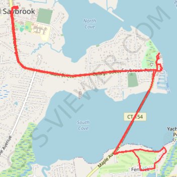
Beeline Lunch ride 19-08-2023
- Distance: 7.3 mi
- Elevation gain: 52 m
- Maximum elevation: 10 m
- Elevation loss: 52 m
- Minimum elevation: 0 m
- Moving time: 51 m 13 s
- Moving speed: 8.5 mph
- Maximum speed: 15.1 mph
- Total time: 1 h 54 m
- Global speed: 3.8 mph
Interactive trail map
Thank you for supporting this site ❤️
Make a donation
Make a donation
Gear up for your next adventure:
As an Amazon Associate, this site earns from qualifying purchases at no extra cost to you.
Trail profile
- Distance: 7.3 mi
- Elevation gain: 52 m
- Maximum elevation: 10 m
- Elevation loss: 52 m
- Minimum elevation: 0 m
- Moving time: 51 m 13 s
- Moving speed: 8.5 mph
- Maximum speed: 15.1 mph
- Total time: 1 h 54 m
- Global speed: 3.8 mph
Thank you for supporting this site ❤️
Make a donation
Make a donation
Gear up for your next adventure:
As an Amazon Associate, this site earns from qualifying purchases at no extra cost to you.
About this trail
Name: Beeline Lunch ride 19-08-2023 trail, distance, elevation, map, profile, GPS track
Coordinates: 41.27080 -72.37635 41.29234 -72.34916
Thank you for supporting this site ❤️
Make a donation
Make a donation
Gear up for your next adventure:
As an Amazon Associate, this site earns from qualifying purchases at no extra cost to you.