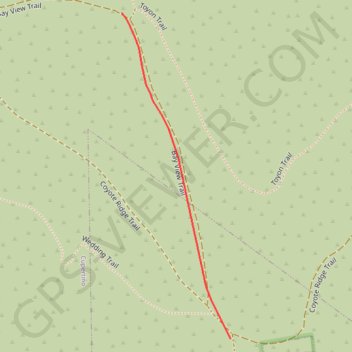
Insta360 GPS Data
- Distance: 0.2 mi
- Elevation gain: 6 m
- Maximum elevation: 321 m
- Elevation loss: 1 m
- Minimum elevation: 315 m
- Moving time: 1 m 28 s
- Moving speed: 6.4 mph
- Maximum speed: 9.7 mph
- Total time: 1 m 28 s
- Global speed: 6.4 mph
Interactive trail map
Trail profile
- Distance: 0.2 mi
- Elevation gain: 6 m
- Maximum elevation: 321 m
- Elevation loss: 1 m
- Minimum elevation: 315 m
- Moving time: 1 m 28 s
- Moving speed: 6.4 mph
- Maximum speed: 9.7 mph
- Total time: 1 m 28 s
- Global speed: 6.4 mph
About this trail
Name: Insta360 GPS Data trail, distance, elevation, map, profile, GPS track
Start: Bay View Trail, Cupertino, Santa Clara County, California, United States (37.28187 -122.06357)
End: Coyote Ridge Trail, Santa Clara County, California, United States (37.27974 -122.06268)
Coordinates: 37.27974 -122.06357 37.28187 -122.06268