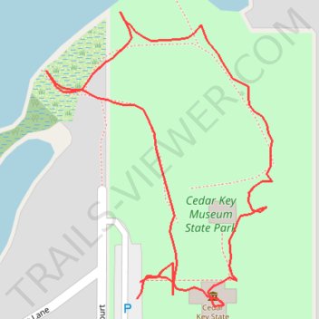
Cedar Key Museum Trail walk
- Distance: 0.5 mi
- Elevation gain: 11 m
- Maximum elevation: 14 m
- Elevation loss: 11 m
- Minimum elevation: 2 m
- Moving time: 13 m 5 s
- Moving speed: 2.2 mph
- Maximum speed: 8.8 mph
- Total time: 25 m 37 s
- Global speed: 1.1 mph
Interactive trail map
Trail profile
- Distance: 0.5 mi
- Elevation gain: 11 m
- Maximum elevation: 14 m
- Elevation loss: 11 m
- Minimum elevation: 2 m
- Moving time: 13 m 5 s
- Moving speed: 2.2 mph
- Maximum speed: 8.8 mph
- Total time: 25 m 37 s
- Global speed: 1.1 mph
About this trail
Name: Cedar Key Museum Trail walk trail, distance, elevation, map, profile, GPS track
Start: Southwest 166th Court, Cedar Key, Levy County, Florida, 32625, United States (29.15070 -83.04854)
End: Southwest 166th Court, Cedar Key, Levy County, Florida, 32625, United States (29.15060 -83.04856)
Coordinates: 29.15055 -83.04920 29.15236 -83.04761