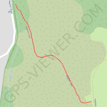
Insta360 GPS Data
- Distance: 0.2 mi
- Elevation gain: 53 m
- Maximum elevation: 255 m
- Elevation loss: 0 m
- Minimum elevation: 202 m
- Moving time: 4 m 18 s
- Moving speed: 3.1 mph
- Maximum speed: 4.9 mph
- Total time: 4 m 18 s
- Global speed: 3.1 mph
Interactive trail map
Trail profile
- Distance: 0.2 mi
- Elevation gain: 53 m
- Maximum elevation: 255 m
- Elevation loss: 0 m
- Minimum elevation: 202 m
- Moving time: 4 m 18 s
- Moving speed: 3.1 mph
- Maximum speed: 4.9 mph
- Total time: 4 m 18 s
- Global speed: 3.1 mph
About this trail
Name: Insta360 GPS Data trail, distance, elevation, map, profile, GPS track
Start: Regnart Trail, Cupertino, Santa Clara County, California, United States (37.29301 -122.06231)
End: Regnart Trail, Cupertino, Santa Clara County, California, United States (37.29077 -122.06011)
Coordinates: 37.29074 -122.06231 37.29301 -122.06011