Make a donation
Gear up for your next adventure:
As an Amazon Associate, this site earns from qualifying purchases at no extra cost to you.
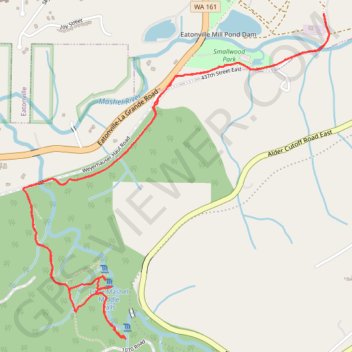
Little Mashel Falls Trail via Bud Blancher Trail
The Bud Blancher Trail to Little Mashel Falls offers hikers a journey through serene forested areas, leading to the impressive Upper, Middle, and Lower Falls. The trail is well-maintained, though it can become muddy and slippery near the waterfalls, so appropriate footwear is recommended. #Hiking #Waterfall #Forest #Nature #River
- Distance: 4.2 mi
- Elevation gain: 201 m
- Maximum elevation: 344 m
- Elevation loss: 202 m
- Minimum elevation: 236 m
- Moving time: 1 h 43 m
- Moving speed: 2.4 mph
- Maximum speed: 4.9 mph
- Total time: 1 h 50 m
- Global speed: 2.3 mph
Interactive trail map
Make a donation
Gear up for your next adventure:
As an Amazon Associate, this site earns from qualifying purchases at no extra cost to you.
Trail profile
- Distance: 4.2 mi
- Elevation gain: 201 m
- Maximum elevation: 344 m
- Elevation loss: 202 m
- Minimum elevation: 236 m
- Moving time: 1 h 43 m
- Moving speed: 2.4 mph
- Maximum speed: 4.9 mph
- Total time: 1 h 50 m
- Global speed: 2.3 mph
Make a donation
Gear up for your next adventure:
As an Amazon Associate, this site earns from qualifying purchases at no extra cost to you.
About this trail
Name: Little Mashel Falls Trail via Bud Blancher Trail trail, distance, elevation, map, profile, GPS track
Coordinates: 46.84691 -122.27870 46.86161 -122.25854
Make a donation
Gear up for your next adventure:
As an Amazon Associate, this site earns from qualifying purchases at no extra cost to you.