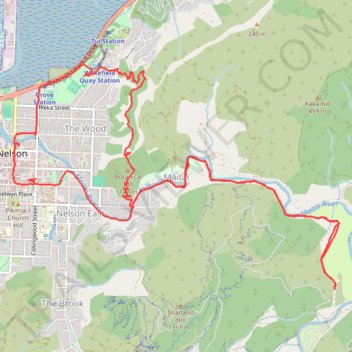
Nelson, Maitai Valley
- Distance: 10.9 mi
- Elevation gain: 468 m
- Maximum elevation: 169 m
- Elevation loss: 467 m
- Minimum elevation: 4 m
- Moving time: 4 h 19 m
- Moving speed: 2.5 mph
- Maximum speed: 8.5 mph
- Total time: 7 h 32 m
- Global speed: 1.4 mph
Interactive trail map
Trail profile
- Distance: 10.9 mi
- Elevation gain: 468 m
- Maximum elevation: 169 m
- Elevation loss: 467 m
- Minimum elevation: 4 m
- Moving time: 4 h 19 m
- Moving speed: 2.5 mph
- Maximum speed: 8.5 mph
- Total time: 7 h 32 m
- Global speed: 1.4 mph
About this trail
Name: Nelson, Maitai Valley trail, distance, elevation, map, profile, GPS track
Start: Buxton Carpark, Alma Street, Nelson East, Nelson, 7010, New Zealand (-41.27386 173.28594)
End: Collingwood Street, Nelson East, Nelson, 7042, New Zealand (-41.27376 173.28700)
Coordinates: -41.28517 173.28388 -41.26174 173.32854
Other hiking, mountain biking, running and outdoor activity trails
Click on a trail to view its statistics, map and profile.
Loop around Centre of NZ, Maitai Valley, Branford Park
New Zealand > Nelson > Nelson
Distance: 5.2 mi • Elevation gain: 274 m • Maximum elevation: 168 m