Make a donation
Gear up for your next adventure:
As an Amazon Associate, this site earns from qualifying purchases at no extra cost to you.
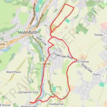
Ribble and Holmfirth Cliff
- Distance: 3.7 mi
- Elevation gain: 142 m
- Maximum elevation: 276 m
- Elevation loss: 143 m
- Minimum elevation: 180 m
- Moving time: 1 h 57 m
- Moving speed: 1.9 mph
- Maximum speed: 2.8 mph
- Total time: 2 h 26 m
- Global speed: 1.5 mph
Interactive trail map
Make a donation
Gear up for your next adventure:
As an Amazon Associate, this site earns from qualifying purchases at no extra cost to you.
Trail profile
- Distance: 3.7 mi
- Elevation gain: 142 m
- Maximum elevation: 276 m
- Elevation loss: 143 m
- Minimum elevation: 180 m
- Moving time: 1 h 57 m
- Moving speed: 1.9 mph
- Maximum speed: 2.8 mph
- Total time: 2 h 26 m
- Global speed: 1.5 mph
Make a donation
Gear up for your next adventure:
As an Amazon Associate, this site earns from qualifying purchases at no extra cost to you.
About this trail
Name: Ribble and Holmfirth Cliff trail, distance, elevation, map, profile, GPS track
Coordinates: 53.55759 -1.78636 53.57547 -1.77195
Topography: Kirklees topographic map, elevation, terrain
Make a donation
Gear up for your next adventure:
As an Amazon Associate, this site earns from qualifying purchases at no extra cost to you.
Other hiking, mountain biking, running and outdoor activity trails
Click on a trail to view its statistics, map and profile.
Washpit Mill via Holmfirth and Wooldale
United Kingdom > England > Kirklees > Holmfirth > Washpit Mill
Distance: 3.3 mi • Elevation gain: 127 m • Maximum elevation: 277 m
Cartworth Moor checkout
United Kingdom > England > Kirklees > Holmfirth > Washpit Mill
Distance: 2.7 mi • Elevation gain: 136 m • Maximum elevation: 327 m
Cartworth Moor Loop
United Kingdom > England > Kirklees > Holmfirth > Washpit Mill
Distance: 3.5 mi • Elevation gain: 157 m • Maximum elevation: 346 m