Thank you for supporting this site ❤️
Make a donation
Make a donation
Gear up for your next adventure:
As an Amazon Associate, this site earns from qualifying purchases at no extra cost to you.
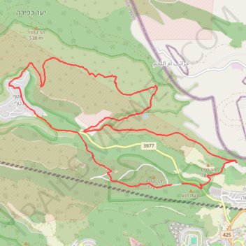
קוצים ומעלה אייק בכפירה
- Distance: 8.9 mi
- Elevation gain: 592 m
- Maximum elevation: 774 m
- Elevation loss: 598 m
- Minimum elevation: 395 m
- Moving time: 2 h 35 m
- Moving speed: 3.4 mph
- Maximum speed: 8.1 mph
- Total time: 3 h 8 m
- Global speed: 2.8 mph
Interactive trail map
Thank you for supporting this site ❤️
Make a donation
Make a donation
Gear up for your next adventure:
As an Amazon Associate, this site earns from qualifying purchases at no extra cost to you.
Trail profile
- Distance: 8.9 mi
- Elevation gain: 592 m
- Maximum elevation: 774 m
- Elevation loss: 598 m
- Minimum elevation: 395 m
- Moving time: 2 h 35 m
- Moving speed: 3.4 mph
- Maximum speed: 8.1 mph
- Total time: 3 h 8 m
- Global speed: 2.8 mph
Thank you for supporting this site ❤️
Make a donation
Make a donation
Gear up for your next adventure:
As an Amazon Associate, this site earns from qualifying purchases at no extra cost to you.
About this trail
Name: קוצים ומעלה אייק בכפירה trail, distance, elevation, map, profile, GPS track
Start: Mate Yehuda Regional Council, Jerusalem Subdistrict, Jerusalem District, Israel (31.81958 35.09742)
End: Mate Yehuda Regional Council, Jerusalem Subdistrict, Jerusalem District, Israel (31.81945 35.09565)
Coordinates: 31.81887 35.06624 31.83894 35.10736
Thank you for supporting this site ❤️
Make a donation
Make a donation
Gear up for your next adventure:
As an Amazon Associate, this site earns from qualifying purchases at no extra cost to you.