Glen Rose Walking
- Distance: 1.8 mi
- Elevation gain: 22 m
- Maximum elevation: 198 m
- Elevation loss: 22 m
- Minimum elevation: 186 m
- Moving time: 55 m 9 s
- Moving speed: 1.9 mph
- Maximum speed: 3.0 mph
- Total time: 1 h 4 m
- Global speed: 1.6 mph
Interactive trail map
Trail profile
- Distance: 1.8 mi
- Elevation gain: 22 m
- Maximum elevation: 198 m
- Elevation loss: 22 m
- Minimum elevation: 186 m
- Moving time: 55 m 9 s
- Moving speed: 1.9 mph
- Maximum speed: 3.0 mph
- Total time: 1 h 4 m
- Global speed: 1.6 mph
About this trail
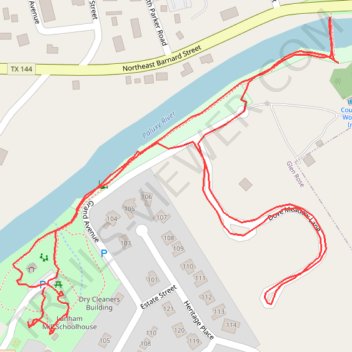
Name: Glen Rose Walking trail, distance, elevation, map, profile, GPS track
Start: Matthews Street, Glen Rose, Somervell County, Texas, 76043, United States (32.23457 -97.75232)
End: Matthews Street, Glen Rose, Somervell County, Texas, 76043, United States (32.23461 -97.75227)
Coordinates: 32.23389 -97.75286 32.23849 -97.74727