Thank you for supporting this site ❤️
Make a donation
Make a donation
Gear up for your next adventure:
As an Amazon Associate, this site earns from qualifying purchases at no extra cost to you.
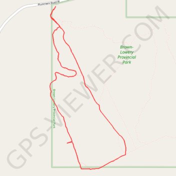
Wild Rose Loop
Interactive trail map
Thank you for supporting this site ❤️
Make a donation
Make a donation
Gear up for your next adventure:
As an Amazon Associate, this site earns from qualifying purchases at no extra cost to you.
Trail profile
- Distance: 3.0 mi
- Elevation gain: 108 m
- Maximum elevation: 1,423 m
- Elevation loss: 108 m
- Minimum elevation: 1,335 m
Thank you for supporting this site ❤️
Make a donation
Make a donation
Gear up for your next adventure:
As an Amazon Associate, this site earns from qualifying purchases at no extra cost to you.
About this trail
Name: Wild Rose Loop trail, distance, elevation, map, profile, GPS track
Start: Plummers Road W, Foothills County, Alberta, Canada (50.82036 -114.43948)
End: Plummers Road W, Foothills County, Alberta, Canada (50.82036 -114.43948)
Coordinates: 50.80476 -114.44033 50.82036 -114.42883
Thank you for supporting this site ❤️
Make a donation
Make a donation
Gear up for your next adventure:
As an Amazon Associate, this site earns from qualifying purchases at no extra cost to you.