Cataract Falls
Interactive trail map
Trail profile
- Distance: 2.9 mi
- Elevation gain: 370 m
- Maximum elevation: 537 m
- Elevation loss: 370 m
- Minimum elevation: 216 m
About this trail
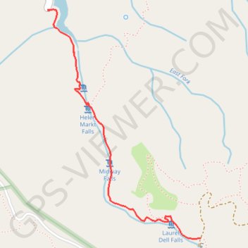
Name: Cataract Falls trail, distance, elevation, map, profile, GPS track
Start: Cataract Trail, Marin County, California, 94970, United States (37.93651 -122.63803)
End: Cataract Trail, Marin County, California, 94970, United States (37.93653 -122.63804)
Coordinates: 37.92340 -122.63804 37.93656 -122.62695
Other hiking, mountain biking, running and outdoor activity trails
Click on a trail to view its statistics, map and profile.
Cataract Falls Trail from Alpine Lake in Mount Tamalpais Watershed
United States > California > Marin County
The Cataract Trail in Mount Tamalpais Watershed offers hikers a serene journey through dense forests, accompanied by the soothing sounds of cascading waterfalls. Along the path, one can observe a series of waterfalls, including Cataract Falls, Helen Markt Falls, Midway Falls, and Laurel Dell Falls, each…
Distance: 3.1 mi • Elevation gain: 370 m • Maximum elevation: 537 m
Point Reyes Loop
United States > California > Marin County > Mill Valley
Distance: 62.3 mi • Elevation gain: 1,900 m • Maximum elevation: 236 m