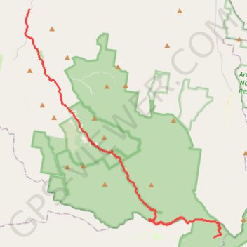
Glen Rock State Forest
Interactive trail map
Trail profile
- Distance: 23.9 mi
- Elevation gain: 383 m
- Maximum elevation: 1,048 m
- Elevation loss: 1,180 m
- Minimum elevation: 217 m
About this trail
Name: Glen Rock State Forest trail, distance, elevation, map, profile, GPS track
Start: Lookout Road, Goomburra, Southern Downs Regional, Queensland, Australia (-27.97797 152.37423)
End: Mount Sylvia Road, Woodbine, Lockyer Valley Regional, Queensland, Australia (-27.77814 152.19166)
Coordinates: -27.97797 152.18751 -27.77814 152.38093
Other hiking, mountain biking, running and outdoor activity trails
Click on a trail to view its statistics, map and profile.
Warwick - Gatton
Australia > Queensland > Warwick
#Bike
Distance: 77.8 mi • Elevation gain: 812 m • Maximum elevation: 582 m
Walk to Glen Rock, QLD
Distance: 3.1 mi • Elevation gain: 463 m • Maximum elevation: 787 m
Black Duck
Distance: 28.4 mi • Elevation gain: 627 m • Maximum elevation: 569 m