Thank you for supporting this site ❤️
Make a donation
Make a donation
Gear up for your next adventure:
As an Amazon Associate, this site earns from qualifying purchases at no extra cost to you.
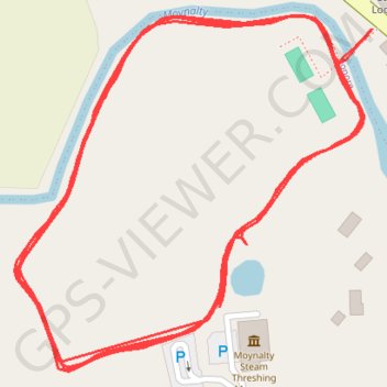
Moynalty Steam Threshing Field
Lunch Run
- Distance: 2.2 mi
- Elevation gain: 32 m
- Maximum elevation: 80 m
- Elevation loss: 35 m
- Minimum elevation: 71 m
- Moving time: 23 m 22 s
- Moving speed: 5.6 mph
- Maximum speed: 7.1 mph
- Total time: 24 m 19 s
- Global speed: 5.4 mph
Interactive trail map
Thank you for supporting this site ❤️
Make a donation
Make a donation
Gear up for your next adventure:
As an Amazon Associate, this site earns from qualifying purchases at no extra cost to you.
Trail profile
- Distance: 2.2 mi
- Elevation gain: 32 m
- Maximum elevation: 80 m
- Elevation loss: 35 m
- Minimum elevation: 71 m
- Moving time: 23 m 22 s
- Moving speed: 5.6 mph
- Maximum speed: 7.1 mph
- Total time: 24 m 19 s
- Global speed: 5.4 mph
Thank you for supporting this site ❤️
Make a donation
Make a donation
Gear up for your next adventure:
As an Amazon Associate, this site earns from qualifying purchases at no extra cost to you.
About this trail
Name: Moynalty Steam Threshing Field trail, distance, elevation, map, profile, GPS track
Coordinates: 53.78781 -6.89223 53.79020 -6.88816
Thank you for supporting this site ❤️
Make a donation
Make a donation
Gear up for your next adventure:
As an Amazon Associate, this site earns from qualifying purchases at no extra cost to you.