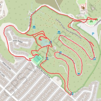
Stough Landfill Park and Stough Canyon Park Loop
Loop hike in Stough Landfill Park and Stough Canyon Park via Bel Aire Ballfield, Birmingham Debris Basin, Haskins Fire Road, Lockheed View Drive and North Bel Aire Drive in Verdugo Mountains. #Hiking #Loop #Park #Nature #Forest #Mountain
- Distance: 3.9 mi
- Elevation gain: 206 m
- Maximum elevation: 399 m
- Elevation loss: 207 m
- Minimum elevation: 254 m
- Moving time: 1 h 45 m
- Moving speed: 2.2 mph
- Maximum speed: 3.8 mph
- Total time: 2 h 2 m
- Global speed: 1.9 mph
Interactive trail map
Trail profile
- Distance: 3.9 mi
- Elevation gain: 206 m
- Maximum elevation: 399 m
- Elevation loss: 207 m
- Minimum elevation: 254 m
- Moving time: 1 h 45 m
- Moving speed: 2.2 mph
- Maximum speed: 3.8 mph
- Total time: 2 h 2 m
- Global speed: 1.9 mph
About this trail
Name: Stough Landfill Park and Stough Canyon Park Loop trail, distance, elevation, map, profile, GPS track
Coordinates: 34.19937 -118.31794 34.20671 -118.30870
Other hiking, mountain biking, running and outdoor activity trails
Click on a trail to view its statistics, map and profile.
Verdugo Mountains Full Ridge
United States > California > Los Angeles County > Los Angeles
Hike on the Verdugo Mountains via Village Avenue Trail, La Tuna Peak, Chandler Mtrwy, Boy Scout Camp, Verdugo Motorway, Verdugo Crest Trail, Tree of Life, Wildhos Saddle, Verdugo Peak, Mesa Lila Road, Mount Thom and Las Flores Motorway. #Hiking #Mountain #Nature #Forest #Park
Distance: 14.5 mi • Elevation gain: 1,174 m • Maximum elevation: 946 m