Import a GPX file

Flemming Park Trail Running

Loop run / hike in Flemming Park. #Running #Hiking #Loop #Nature #Park #Forest

  • Distance: 3.4 mi
  • Elevation gain: 57 m
  • Maximum elevation: 295 m
  • Elevation loss: 59 m
  • Minimum elevation: 272 m
  • Moving time: 51 m 51 s
  • Moving speed: 4.0 mph
  • Maximum speed: 6.0 mph
  • Total time: 51 m 51 s
  • Global speed: 4.0 mph

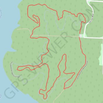
Interactive trail map

Trail profile

  • Distance: 3.4 mi
  • Elevation gain: 57 m
  • Maximum elevation: 295 m
  • Elevation loss: 59 m
  • Minimum elevation: 272 m
  • Moving time: 51 m 51 s
  • Moving speed: 4.0 mph
  • Maximum speed: 6.0 mph
  • Total time: 51 m 51 s
  • Global speed: 4.0 mph

About this trail

Name: Flemming Park Trail Running trail, distance, elevation, map, profile, GPS track

Start: Larry Mattonen Memorial Trail, Jackson County, Missouri, 64139, United States (38.95587 -94.31545)

End: Larry Mattonen Memorial Trail, Jackson County, Missouri, 64139, United States (38.95622 -94.31539)

Coordinates: 38.94966 -94.32345 38.95920 -94.31461

Gear up for your next adventure:

🧭Professional Hiking Compasses - High-precision liquid-filled compasses for map reading and orientation
🎿Telescopic Trekking Poles - Reduces knee strain on steep topographic descents
Lightweight Tents - Compact tents for backpacking and trekking
🔭Compact Hiking Binoculars - Lightweight optics for scouting terrain and spotting wildlife
🔋Lithium AA Batteries - Long-lasting power that performs well in cold mountain weather

As an Amazon Associate, this site earns from qualifying purchases at no extra cost to you.