Minneopa State Park
Minneola State Park, Seppmann mill trail
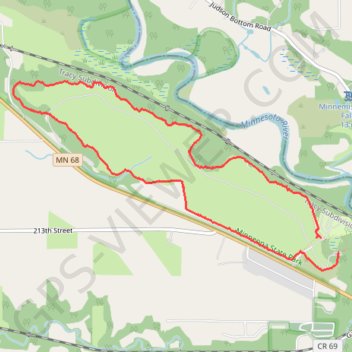
- Distance: 5.1 mi
- Elevation gain: 65 m
- Maximum elevation: 273 m
- Elevation loss: 67 m
- Minimum elevation: 251 m
- Moving time: 2 h 13 m
- Moving speed: 2.3 mph
- Maximum speed: 3.4 mph
- Total time: 2 h 41 m
- Global speed: 1.9 mph
Interactive trail map
Trail profile
- Distance: 5.1 mi
- Elevation gain: 65 m
- Maximum elevation: 273 m
- Elevation loss: 67 m
- Minimum elevation: 251 m
- Moving time: 2 h 13 m
- Moving speed: 2.3 mph
- Maximum speed: 3.4 mph
- Total time: 2 h 41 m
- Global speed: 1.9 mph
About this trail
Name: Minneopa State Park trail, distance, elevation, map, profile, GPS track
Start: Seppmann Mill Trail, Blue Earth County, Minnesota, United States (44.15855 -94.08815)
End: Wetland Loop Trail, Blue Earth County, Minnesota, United States (44.15731 -94.08625)
Coordinates: 44.15591 -94.12298 44.17120 -94.08625