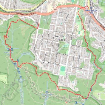
Wentworth Falls Loop
Blue Mountains National Park. #Hiking #Loop #BlueMountains
- Distance: 4.3 mi
- Elevation gain: 188 m
- Maximum elevation: 916 m
- Elevation loss: 233 m
- Minimum elevation: 794 m
- Moving time: 2 h 9 m
- Moving speed: 2.0 mph
- Maximum speed: 4.7 mph
- Total time: 2 h 46 m
- Global speed: 1.5 mph
Interactive trail map
Trail profile
- Distance: 4.3 mi
- Elevation gain: 188 m
- Maximum elevation: 916 m
- Elevation loss: 233 m
- Minimum elevation: 794 m
- Moving time: 2 h 9 m
- Moving speed: 2.0 mph
- Maximum speed: 4.7 mph
- Total time: 2 h 46 m
- Global speed: 1.5 mph
About this trail
Name: Wentworth Falls Loop trail, distance, elevation, map, profile, GPS track
Coordinates: -33.72713 150.35655 -33.70967 150.37876
Other hiking, mountain biking, running and outdoor activity trails
Click on a trail to view its statistics, map and profile.
Mount Solitary - Kedumba Valley
Australia > New South Wales > Sydney > Katoomba
Blue Mountains National Park. #Hiking #Loop #BlueMountains
Distance: 21.7 mi • Elevation gain: 2,492 m • Maximum elevation: 983 m
Sublime Point Trail from Wentworth Falls to Katoomba
Australia > New South Wales > Sydney
Distance: 17.6 mi • Elevation gain: 1,364 m • Maximum elevation: 1,022 m