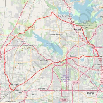
North Texas Trails Initiative Project
- Distance: 71.6 mi
- Elevation gain: 471 m
- Maximum elevation: 231 m
- Elevation loss: 471 m
- Minimum elevation: 134 m
Interactive trail map
Trail profile
- Distance: 71.6 mi
- Elevation gain: 471 m
- Maximum elevation: 231 m
- Elevation loss: 471 m
- Minimum elevation: 134 m
About this trail
Name: North Texas Trails Initiative Project trail, distance, elevation, map, profile, GPS track
Start: Ball Street, Grapevine, Tarrant County, Texas, 76051, United States (32.93242 -97.08415)
End: Cottonbelt Trail, Grapevine, Tarrant County, Texas, 76051, United States (32.93242 -97.08412)
Coordinates: 32.83560 -97.29552 33.10486 -96.90887
Other hiking, mountain biking, running and outdoor activity trails
Click on a trail to view its statistics, map and profile.
Lake Carolyn Promenade
United States > Texas > Dallas County > Irving
Distance: 2.5 mi • Elevation gain: 29 m • Maximum elevation: 136 m