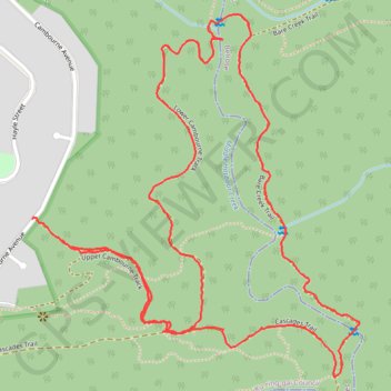
Import a GPX file

The Cambourne Loop

Garigal National Park. #Hiking #Loop #Garigal

  • Distance: 2.8 mi
  • Elevation gain: 139 m
  • Maximum elevation: 135 m
  • Elevation loss: 130 m
  • Minimum elevation: 37 m
  • Moving time: 1 h 14 m
  • Moving speed: 2.2 mph
  • Maximum speed: 5.4 mph
  • Total time: 1 h 22 m
  • Global speed: 2.0 mph

Interactive trail map

Trail profile

  • Distance: 2.8 mi
  • Elevation gain: 139 m
  • Maximum elevation: 135 m
  • Elevation loss: 130 m
  • Minimum elevation: 37 m
  • Moving time: 1 h 14 m
  • Moving speed: 2.2 mph
  • Maximum speed: 5.4 mph
  • Total time: 1 h 22 m
  • Global speed: 2.0 mph

About this trail

Other hiking, mountain biking, running and outdoor activity trails

Click on a trail to view its statistics, map and profile.

Ettalong

Australia > New South Wales > Sydney

Bike loop from St Ives. Ku-ring-gai Chase National Park. Brisbane Water National Park. Garigal National Park. #Bike #Loop

Distance: 83.3 mi • Elevation gain: 2,140 m • Maximum elevation: 228 m

Gear up for your next adventure:

🕶️Glacier Goggles - Maximum protection for high-altitude snow topography
🥾Hiking Boots - Waterproof and durable boots for long-distance hiking in the UK
🔋Lithium AA Batteries - Long-lasting power that performs well in cold mountain weather
🖼️Topographic Map Art - Decorative 3D-effect posters of famous UK peaks and regions
📷Camera Straps - Secure straps for carrying cameras while walking

As an Amazon Associate, this site earns from qualifying purchases at no extra cost to you.