Thank you for supporting this site ❤️
Make a donation
Make a donation
Gear up for your next adventure:
As an Amazon Associate, this site earns from qualifying purchases at no extra cost to you.
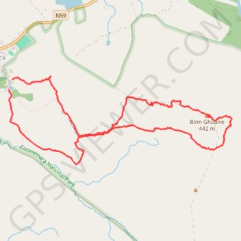
Diamond Hill
Connemara National Park. #Hiking #Loop #DiamondHill #Connemara
- Distance: 4.4 mi
- Elevation gain: 396 m
- Maximum elevation: 435 m
- Elevation loss: 393 m
- Minimum elevation: 53 m
- Moving time: 2 h 6 s
- Moving speed: 2.2 mph
- Maximum speed: 4.6 mph
- Total time: 2 h 29 m
- Global speed: 1.8 mph
Interactive trail map
Thank you for supporting this site ❤️
Make a donation
Make a donation
Gear up for your next adventure:
As an Amazon Associate, this site earns from qualifying purchases at no extra cost to you.
Trail profile
- Distance: 4.4 mi
- Elevation gain: 396 m
- Maximum elevation: 435 m
- Elevation loss: 393 m
- Minimum elevation: 53 m
- Moving time: 2 h 6 s
- Moving speed: 2.2 mph
- Maximum speed: 4.6 mph
- Total time: 2 h 29 m
- Global speed: 1.8 mph
Thank you for supporting this site ❤️
Make a donation
Make a donation
Gear up for your next adventure:
As an Amazon Associate, this site earns from qualifying purchases at no extra cost to you.
About this trail
Name: Diamond Hill trail, distance, elevation, map, profile, GPS track
Coordinates: 53.54377 -9.94498 53.55180 -9.91085
Thank you for supporting this site ❤️
Make a donation
Make a donation
Gear up for your next adventure:
As an Amazon Associate, this site earns from qualifying purchases at no extra cost to you.