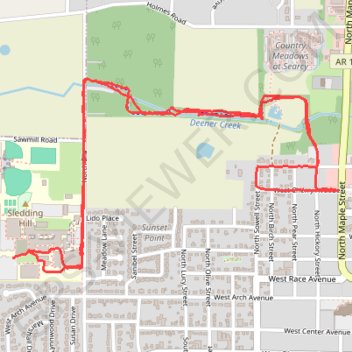
Western Portion of Searcy Bike Trail and Searcy High School
Evening Ride
- Distance: 4.0 mi
- Elevation gain: 42 m
- Maximum elevation: 90 m
- Elevation loss: 44 m
- Minimum elevation: 67 m
- Moving time: 31 m 31 s
- Moving speed: 7.5 mph
- Maximum speed: 17.5 mph
- Total time: 45 m 17 s
- Global speed: 5.2 mph
Interactive trail map
Trail profile
- Distance: 4.0 mi
- Elevation gain: 42 m
- Maximum elevation: 90 m
- Elevation loss: 44 m
- Minimum elevation: 67 m
- Moving time: 31 m 31 s
- Moving speed: 7.5 mph
- Maximum speed: 17.5 mph
- Total time: 45 m 17 s
- Global speed: 5.2 mph
About this trail
Name: Western Portion of Searcy Bike Trail and Searcy High School trail, distance, elevation, map, profile, GPS track
Coordinates: 35.25113 -91.76127 35.25884 -91.74532