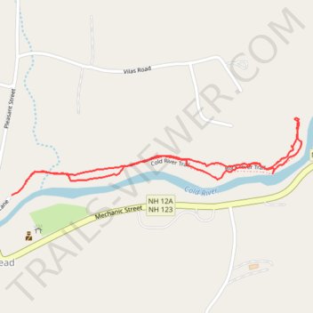
Cold river trail
- Distance: 1.2 mi
- Elevation gain: 38 m
- Maximum elevation: 170 m
- Elevation loss: 38 m
- Minimum elevation: 147 m
- Moving time: 53 m 47 s
- Moving speed: 1.4 mph
- Maximum speed: 3.7 mph
- Total time: 54 m 28 s
- Global speed: 1.3 mph
Interactive trail map
Trail profile
- Distance: 1.2 mi
- Elevation gain: 38 m
- Maximum elevation: 170 m
- Elevation loss: 38 m
- Minimum elevation: 147 m
- Moving time: 53 m 47 s
- Moving speed: 1.4 mph
- Maximum speed: 3.7 mph
- Total time: 54 m 28 s
- Global speed: 1.3 mph
About this trail
Name: Cold river trail trail, distance, elevation, map, profile, GPS track
Start: Cold River Trail, Alstead, Cheshire County, New Hampshire, 03602, United States (43.15060 -72.36083)
End: Cold River Trail, Alstead, Cheshire County, New Hampshire, 03602, United States (43.15091 -72.36037)
Coordinates: 43.15060 -72.36083 43.15249 -72.35109
Other hiking, mountain biking, running and outdoor activity trails
Click on a trail to view its statistics, map and profile.