Make a donation
Gear up for your next adventure:
As an Amazon Associate, this site earns from qualifying purchases at no extra cost to you.
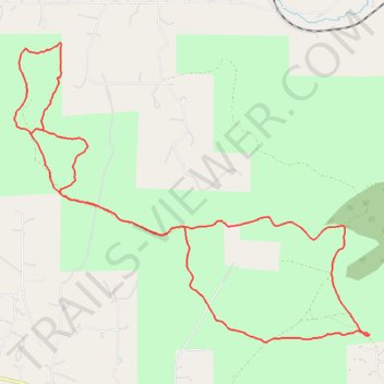
Scratchgravel Hills Mountain Biking
- Distance: 8.7 mi
- Elevation gain: 383 m
- Maximum elevation: 1,433 m
- Elevation loss: 383 m
- Minimum elevation: 1,312 m
- Moving time: 1 h 29 m
- Moving speed: 5.9 mph
- Maximum speed: 23.5 mph
- Total time: 1 h 42 m
- Global speed: 5.1 mph
Interactive trail map
Make a donation
Gear up for your next adventure:
As an Amazon Associate, this site earns from qualifying purchases at no extra cost to you.
Trail profile
- Distance: 8.7 mi
- Elevation gain: 383 m
- Maximum elevation: 1,433 m
- Elevation loss: 383 m
- Minimum elevation: 1,312 m
- Moving time: 1 h 29 m
- Moving speed: 5.9 mph
- Maximum speed: 23.5 mph
- Total time: 1 h 42 m
- Global speed: 5.1 mph
Make a donation
Gear up for your next adventure:
As an Amazon Associate, this site earns from qualifying purchases at no extra cost to you.
About this trail
Name: Scratchgravel Hills Mountain Biking trail, distance, elevation, map, profile, GPS track
Start: Scratch Gravels Doubletrack, Lewis and Clark County, Montana, United States (46.66803 -112.09461)
End: Scratch Gravels Doubletrack, Lewis and Clark County, Montana, United States (46.66801 -112.09467)
Coordinates: 46.66732 -112.14388 46.69590 -112.09461
Make a donation
Gear up for your next adventure:
As an Amazon Associate, this site earns from qualifying purchases at no extra cost to you.
Other hiking, mountain biking, running and outdoor activity trails
Click on a trail to view its statistics, map and profile.
Scratchgravel Loop MTB
United States > Montana > Lewis and Clark County
Distance: 6.1 mi • Elevation gain: 228 m • Maximum elevation: 1,389 m