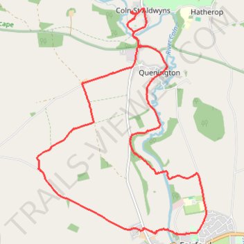
Fairford - Coln St Aldwyns
- Distance: 9.0 mi
- Elevation gain: 144 m
- Maximum elevation: 132 m
- Elevation loss: 144 m
- Minimum elevation: 87 m
- Moving time: 2 h 55 m
- Moving speed: 3.1 mph
- Maximum speed: 5.5 mph
- Total time: 3 h 3 m
- Global speed: 2.9 mph
Interactive trail map
Trail profile
- Distance: 9.0 mi
- Elevation gain: 144 m
- Maximum elevation: 132 m
- Elevation loss: 144 m
- Minimum elevation: 87 m
- Moving time: 2 h 55 m
- Moving speed: 3.1 mph
- Maximum speed: 5.5 mph
- Total time: 3 h 3 m
- Global speed: 2.9 mph
About this trail
Name: Fairford - Coln St Aldwyns trail, distance, elevation, map, profile, GPS track
Coordinates: 51.70953 -1.81797 51.74550 -1.77434
Topography: Cotswold District topographic map, elevation, terrain
Other hiking, mountain biking, running and outdoor activity trails
Click on a trail to view its statistics, map and profile.
Fairford and Water Park
United Kingdom > England > Gloucestershire > Cotswold District > Fairford
Distance: 6.6 mi • Elevation gain: 67 m • Maximum elevation: 113 m
Dean2023-311
United Kingdom > England > Oxfordshire > Oxford
Distance: 192.8 mi • Elevation gain: 3,366 m • Maximum elevation: 290 m