Gnomadic
Downhill only mountain bike trail by The Dirt Concern (rating blue freeride-intermediate).
- Distance: 1.9 mi
- Elevation gain: 6 m
- Maximum elevation: 2,116 m
- Elevation loss: 267 m
- Minimum elevation: 1,854 m
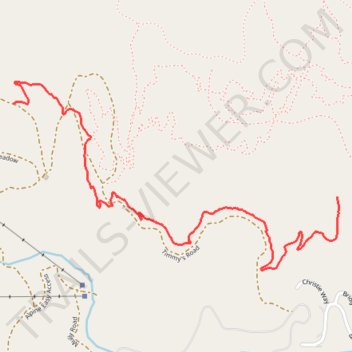
Interactive trail map
Trail profile
- Distance: 1.9 mi
- Elevation gain: 6 m
- Maximum elevation: 2,116 m
- Elevation loss: 267 m
- Minimum elevation: 1,854 m
About this trail
Name: Gnomadic trail, distance, elevation, map, profile, GPS track
Start: Montagne Meadow, Gallatin County, Montana, United States (45.82873 -110.91229)
End: Five Rings Road, Gallatin County, Montana, United States (45.82523 -110.89487)
Coordinates: 45.82249 -110.91229 45.82954 -110.89477
Other hiking, mountain biking, running and outdoor activity trails
Click on a trail to view its statistics, map and profile.
Big Thigh Country
United States > Montana > Gallatin County
Multi-directional mountain bike trail by The Dirt Concern (rating green-beginner).
Distance: 2.8 mi • Elevation gain: 281 m • Maximum elevation: 2,116 m
Golden Rule
United States > Montana > Gallatin County
Multi-directional mountain bike trail by The Dirt Concern (rating green-beginner)
Distance: 1.3 mi • Elevation gain: 39 m • Maximum elevation: 1,858 m