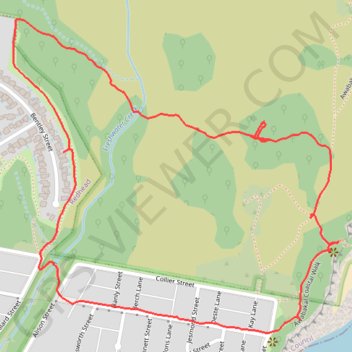
New Awabakal Nature Reserve Fire trail
Lunch Walk
- Distance: 2.2 mi
- Elevation gain: 98 m
- Maximum elevation: 63 m
- Elevation loss: 96 m
- Minimum elevation: 18 m
- Moving time: 54 m 34 s
- Moving speed: 2.4 mph
- Maximum speed: 4.0 mph
- Total time: 1 h 14 m
- Global speed: 1.8 mph
Interactive trail map
Trail profile
- Distance: 2.2 mi
- Elevation gain: 98 m
- Maximum elevation: 63 m
- Elevation loss: 96 m
- Minimum elevation: 18 m
- Moving time: 54 m 34 s
- Moving speed: 2.4 mph
- Maximum speed: 4.0 mph
- Total time: 1 h 14 m
- Global speed: 1.8 mph
About this trail
Name: New Awabakal Nature Reserve Fire trail trail, distance, elevation, map, profile, GPS track
Coordinates: -33.01174 151.71784 -33.00392 151.72751
Other hiking, mountain biking, running and outdoor activity trails
Click on a trail to view its statistics, map and profile.
Broadmeadow - Readhead Beach - Belmont
Australia > New South Wales > Newcastle-Maitland
Fernleigh Track. #Bike
Distance: 22.8 mi • Elevation gain: 264 m • Maximum elevation: 98 m
Fernleigh Rail Trail
Australia > New South Wales > Newcastle-Maitland > Belmont
#Bike
Distance: 13.1 mi • Elevation gain: 160 m • Maximum elevation: 98 m