Aurland Landeveissykling
- Distance: 29.6 mi
- Elevation gain: 794 m
- Maximum elevation: 1,312 m
- Elevation loss: 2,100 m
- Minimum elevation: 0 m
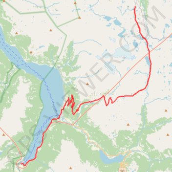
Interactive trail map
Trail profile
- Distance: 29.6 mi
- Elevation gain: 794 m
- Maximum elevation: 1,312 m
- Elevation loss: 2,100 m
- Minimum elevation: 0 m
About this trail
Name: Aurland Landeveissykling trail, distance, elevation, map, profile, GPS track
Start: Bjørgavegen, Aurland, Vestland, Norway (60.92459 7.30964)
End: 9, Nedre Fretheim, Brekke, Flåm, Aurland, Vestland, 5743, Norway (60.86196 7.11348)
Coordinates: 60.86025 7.11348 61.00773 7.36217