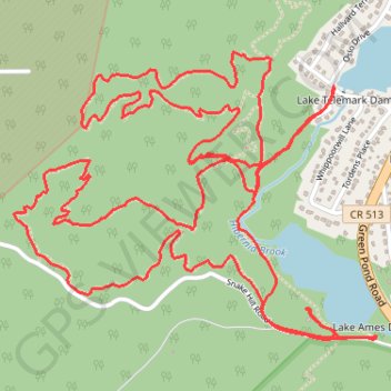
Wildcat Ridge Westie
- Distance: 6.0 mi
- Elevation gain: 223 m
- Maximum elevation: 287 m
- Elevation loss: 223 m
- Minimum elevation: 198 m
- Moving time: 1 h 23 m
- Moving speed: 4.3 mph
- Maximum speed: 16.3 mph
- Total time: 1 h 42 m
- Global speed: 3.5 mph
Interactive trail map
Trail profile
- Distance: 6.0 mi
- Elevation gain: 223 m
- Maximum elevation: 287 m
- Elevation loss: 223 m
- Minimum elevation: 198 m
- Moving time: 1 h 23 m
- Moving speed: 4.3 mph
- Maximum speed: 16.3 mph
- Total time: 1 h 42 m
- Global speed: 3.5 mph
About this trail
Name: Wildcat Ridge Westie trail, distance, elevation, map, profile, GPS track
Coordinates: 40.95110 -74.51495 40.96012 -74.50001
Other hiking, mountain biking, running and outdoor activity trails
Click on a trail to view its statistics, map and profile.
Wildcat Ridge Wildlife Management Area - Lake Telemark Loop
United States > New Jersey > Morris County > Rockaway Township > Lake Telemark > Hibernia
Distance: 11.3 mi • Elevation gain: 370 m • Maximum elevation: 287 m
Lake Ames Park
United States > New Jersey > Morris County > Rockaway Township > Lake Telemark
Distance: 1.7 mi • Elevation gain: 70 m • Maximum elevation: 249 m
Wildcat Ridge Loop
United States > New Jersey > Morris County > Rockaway Township > Hibernia
Distance: 18.3 mi • Elevation gain: 615 m • Maximum elevation: 312 m
Cogswell Mine
United States > New Jersey > Morris County > Rockaway Township > Lake Telemark
Distance: 1.2 mi • Elevation gain: 47 m • Maximum elevation: 269 m