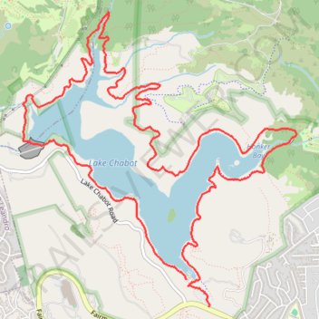
Walking around Lake Chabot
- Distance: 9.0 mi
- Elevation gain: 520 m
- Maximum elevation: 178 m
- Elevation loss: 533 m
- Minimum elevation: 68 m
- Moving time: 2 h 46 m
- Moving speed: 3.3 mph
- Maximum speed: 8.0 mph
- Total time: 3 h 13 m
- Global speed: 2.8 mph
Interactive trail map
Trail profile
- Distance: 9.0 mi
- Elevation gain: 520 m
- Maximum elevation: 178 m
- Elevation loss: 533 m
- Minimum elevation: 68 m
- Moving time: 2 h 46 m
- Moving speed: 3.3 mph
- Maximum speed: 8.0 mph
- Total time: 3 h 13 m
- Global speed: 2.8 mph
About this trail
Name: Walking around Lake Chabot trail, distance, elevation, map, profile, GPS track
Coordinates: 37.71457 -122.12371 37.74178 -122.09181
Other hiking, mountain biking, running and outdoor activity trails
Click on a trail to view its statistics, map and profile.
Lake Chabot Loop Trail in Lake Chabot Regional Park
United States > California > Alameda County > Castro Valley
The Lake Chabot Loop via West Shore Trail, Chabot Dam, Bass Cove Trail, Columbine Trail, Honker Bay Trail and East Shore Trail offers a scenic and varied hiking experience, weaving through shaded forests, sunny open trails, and peaceful lakeside paths. Hikers can enjoy sweeping views of Lake Chabot from…
Distance: 8.8 mi • Elevation gain: 464 m • Maximum elevation: 178 m