
Devil's Punchbowl via Spruce Railroad Trail in Olympic National Park
The Spruce Railroad Trail in Olympic National Park offers hikers a serene journey along the northern shore of Lake Crescent, with views of its clear blue waters and lush surrounding forests. Along the path, visitors can explore historic railroad tunnels, including the McFee Tunnel, adding a touch of history to the natural beauty. The trail leads to the Devil's Punchbowl, a popular spot known for its striking teal waters, where some visitors enjoy swimming and cliff-jumping. #Hiking #Mountain #Forest #Nature #Lake
- Distance: 2.5 mi
- Elevation gain: 167 m
- Maximum elevation: 226 m
- Elevation loss: 168 m
- Minimum elevation: 172 m
- Moving time: 54 m 13 s
- Moving speed: 2.8 mph
- Maximum speed: 8.8 mph
- Total time: 54 m 13 s
- Global speed: 2.8 mph
Interactive trail map
Trail profile
- Distance: 2.5 mi
- Elevation gain: 167 m
- Maximum elevation: 226 m
- Elevation loss: 168 m
- Minimum elevation: 172 m
- Moving time: 54 m 13 s
- Moving speed: 2.8 mph
- Maximum speed: 8.8 mph
- Total time: 54 m 13 s
- Global speed: 2.8 mph
About this trail
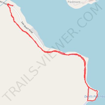
Name: Devil's Punchbowl via Spruce Railroad Trail in Olympic National Park trail, distance, elevation, map, profile, GPS track
Start: East Beach Road, Crescent, Clallam County, Washington, United States (48.09327 -123.80186)
End: East Beach Road, Crescent, Clallam County, Washington, United States (48.09324 -123.80187)
Coordinates: 48.08250 -123.80279 48.09344 -123.78762