Palikū Cabin via Halemau’u Trail
- Distance: 10.5 mi
- Elevation gain: 525 m
- Maximum elevation: 2,429 m
- Elevation loss: 1,004 m
- Minimum elevation: 1,943 m
- Moving time: 4 h 1 m
- Moving speed: 2.6 mph
- Maximum speed: 4.7 mph
- Total time: 4 h 43 m
- Global speed: 2.2 mph
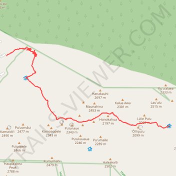
Interactive trail map
Trail profile
- Distance: 10.5 mi
- Elevation gain: 525 m
- Maximum elevation: 2,429 m
- Elevation loss: 1,004 m
- Minimum elevation: 1,943 m
- Moving time: 4 h 1 m
- Moving speed: 2.6 mph
- Maximum speed: 4.7 mph
- Total time: 4 h 43 m
- Global speed: 2.2 mph
About this trail
Name: Palikū Cabin via Halemau’u Trail trail, distance, elevation, map, profile, GPS track
Start: Halemauʻu Trail, Maui County, Hawaii, United States (20.75247 -156.22811)
End: Kaupō Trail, Maui County, Hawaii, United States (20.71789 -156.14250)
Coordinates: 20.71673 -156.22811 20.75656 -156.14190
Other hiking, mountain biking, running and outdoor activity trails
Click on a trail to view its statistics, map and profile.
Pāka'ao'ao from Palikū Cabin
United States > Hawaii > Maui County
Distance: 10.9 mi • Elevation gain: 1,186 m • Maximum elevation: 3,002 m