Thank you for supporting this site ❤️
Make a donation
Make a donation
Gear up for your next adventure:
As an Amazon Associate, this site earns from qualifying purchases at no extra cost to you.
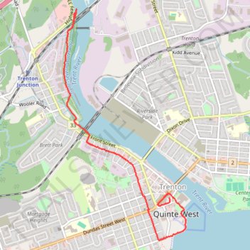
Walk - Trent River
Canada, ON, Trenton Quinte West
- Distance: 3.4 mi
- Elevation gain: 26 m
- Maximum elevation: 86 m
- Elevation loss: 25 m
- Minimum elevation: 74 m
- Moving time: 1 h 18 m
- Moving speed: 2.6 mph
- Maximum speed: 3.3 mph
- Total time: 1 h 38 m
- Global speed: 2.1 mph
Interactive trail map
Thank you for supporting this site ❤️
Make a donation
Make a donation
Gear up for your next adventure:
As an Amazon Associate, this site earns from qualifying purchases at no extra cost to you.
Trail profile
- Distance: 3.4 mi
- Elevation gain: 26 m
- Maximum elevation: 86 m
- Elevation loss: 25 m
- Minimum elevation: 74 m
- Moving time: 1 h 18 m
- Moving speed: 2.6 mph
- Maximum speed: 3.3 mph
- Total time: 1 h 38 m
- Global speed: 2.1 mph
Thank you for supporting this site ❤️
Make a donation
Make a donation
Gear up for your next adventure:
As an Amazon Associate, this site earns from qualifying purchases at no extra cost to you.
About this trail
Name: Walk - Trent River trail, distance, elevation, map, profile, GPS track
Coordinates: 44.09565 -77.59303 44.12253 -77.57330
Thank you for supporting this site ❤️
Make a donation
Make a donation
Gear up for your next adventure:
As an Amazon Associate, this site earns from qualifying purchases at no extra cost to you.
Other hiking, mountain biking, running and outdoor activity trails
Click on a trail to view its statistics, map and profile.
Cobourg - Belleville
Canada > Ontario > Northumberland County > Cobourg
#Bike
Distance: 50.6 mi • Elevation gain: 286 m • Maximum elevation: 118 m