2013BuzetlMartinot
- Distance: 6.9 mi
- Elevation gain: 160 m
- Maximum elevation: 141 m
- Elevation loss: 160 m
- Minimum elevation: 36 m
Interactive trail map
Trail profile
- Distance: 6.9 mi
- Elevation gain: 160 m
- Maximum elevation: 141 m
- Elevation loss: 160 m
- Minimum elevation: 36 m
About this trail
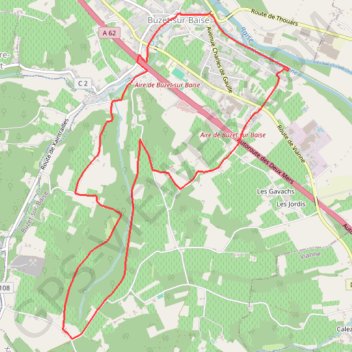
Name: 2013BuzetlMartinot trail, distance, elevation, map, profile, GPS track
Coordinates: 44.22773 0.28407 44.25849 0.31386
Other hiking, mountain biking, running and outdoor activity trails
Click on a trail to view its statistics, map and profile.
Southern section — European Divide Trail
France > Auvergne-Rhône-Alpes > Drôme > Valence
Distance: 1,506.1 mi • Elevation gain: 42,375 m • Maximum elevation: 2,005 m
1 LUCENA - MONTPELLIER
Distance: 1,842.0 mi • Elevation gain: 29,500 m • Maximum elevation: 1,048 m
Chemin de Saint-Jacques-de-Compostelle
Switzerland > Geneva > Geneva
Distance: 694.6 mi • Elevation gain: 25,262 m • Maximum elevation: 1,430 m
2011BuzetBaiseCanal2009
France > Nouvelle-Aquitaine > Lot-et-Garonne > Buzet-sur-Baïse
Distance: 5.2 mi • Elevation gain: 21 m • Maximum elevation: 39 m